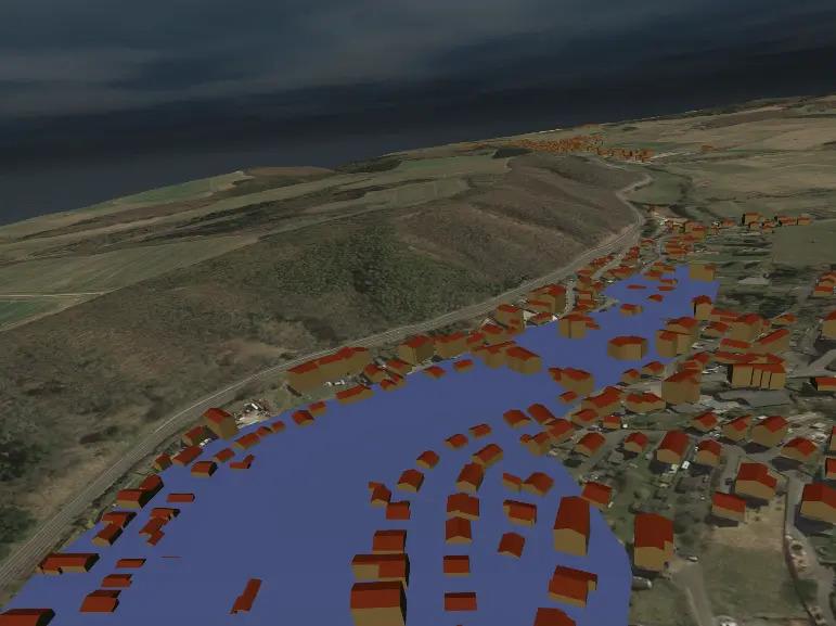
The virtual reality (VR) application simulates realistic flood scenarios in the pilot municipalities. Users experience the effects of heavy rainfall immersively in a virtual environment, which sharpens their perception of risk. The application is based on real geodata and hydrodynamic models. A standardized workflow enables municipalities to create their own simulations.
Use of VR in FloReST
Extreme weather events such as heavy rain and urban flash floods are on the rise in Germany, posing major challenges for cities and municipalities. A key problem is that many citizens only recognize the actual risks when it is already too late. In order to raise awareness of heavy rainfall hazards at an early stage and improve communication about preventive measures, an innovative virtual reality (VR) application was developed at the Birkenfeld Environmental Campus as part of the BMBF project FloReST (Urban Flood Resilience – Smart Tools).
Experience heavy rain up close – what does the VR application do?
The VR application allows users to experience heavy rain events interactively and immersively. Users are virtually immersed in their/a flooded city and see from a first-person perspective how masses of water move through streets and buildings. This impressively conveys the consequences of heavy rain and the measures required to reduce damage.
How was the VR application developed?
Real topographical data and hydrological models were used for the simulation to ensure the most accurate and credible representation of heavy rainfall scenarios possible. The VR environment was created with the Unreal Engine and can be used with standard VR headsets. A standardized approach to data preparation and management with the software Blender ensured that other municipalities will also be able to create their own scenarios and integrate them into the application in the future.
The VR application was tested in several pilot municipalities and used by flood protection and urban planning experts as well as citizens. The results show that the immersive experience increases risk awareness and helps people perceive heavy rainfall as a serious threat.
Why use VR in risk communication?
Traditional maps and warnings are often insufficient to convey the dynamics of heavy rainfall. VR, on the other hand, offers an emotional and memorable experience that promotes not only understanding but also a willingness to take action. The technology can be particularly helpful in citizen participation and municipal planning, where it can be used to illustrate protective measures and support discussions about sustainable solutions.
Test the VR application for yourself!
The VR application developed is available for training courses, information events, and workshops and can be used by municipalities, specialist agencies, or educational institutions.