The data-driven method optimizes groundwater monitoring networks. It identifies redundant monitoring wells or suitable locations for new wells, thereby supporting efficient water-resource management.
Information-based monitoring network optimization helps operators of groundwater monitoring networks evaluate existing structures using data, adapt them in a targeted manner, and further develop them for future monitoring tasks. The aim is to establish a balanced network that provides the highest possible information content while minimizing maintenance and operating costs.
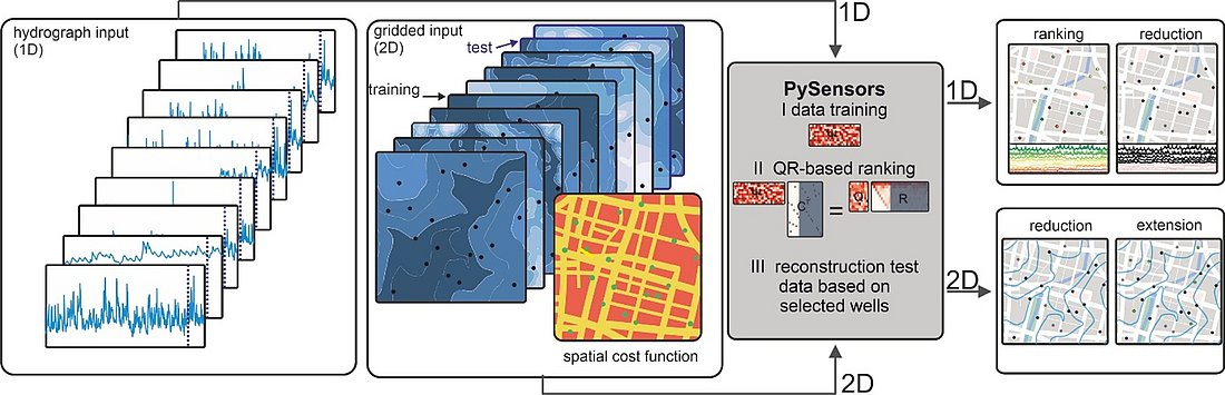
The approach is based on the “Sparse Sensor Placement Optimization for Reconstruction” method (SSPOR), implemented using PySensors. Historical groundwater hydrographs are analyzed to identify recurring patterns and particularly informative dynamics. The monitoring wells are then ranked according to their contribution to the overall system using dimensionality reduction and QR factorization. Rank 1 represents a particularly informative monitoring well.
The ranking can be used to determine which locations are especially important for characterizing the groundwater system and which hydrographs can be reconstructed using higher-ranked monitoring wells. The calculated reconstruction error enables a transparent assessment of potential network reductions and the associated loss of information. Different scenarios—for example, retaining 25, 50, or 75 percent of the highest-ranked monitoring wells—can therefore be compared systematically.
The results support the selection of representative subnetworks, the prioritization of locations for new sensors or data loggers, the adjustment of sampling intervals, and the planning of targeted monitoring campaigns. At the same time, the ranking provides insights into groundwater-system dynamics. Particularly informative monitoring wells often show rapid responses, pronounced fluctuations, and influences from surface waters or human activities. When applied to spatially gridded data, the method can also be used to identify suitable locations for additional monitoring wells.
The approach has already been demonstrated several times for groundwater-level monitoring networks. Within the KIMoDIs project of the LURCH funding initiative, its application was extended to the optimization of a network covering more than one parameter. For this purpose, a combined optimization approach for groundwater-level and groundwater-temperature monitoring networks was developed.
The method requires sufficiently comprehensive spatial and temporal input data that have been processed to form complete datasets without gaps. Because the existing monitoring network is treated as an integrated system, the method does not replace risk-based or inflow-oriented site assessments. Instead, it complements them by providing an objective, information-based basis for decision-making.