CAM online dialogue platform (Coastal Aquifer Management)

#CAM #IWRM #MCDA #Dialogue platform
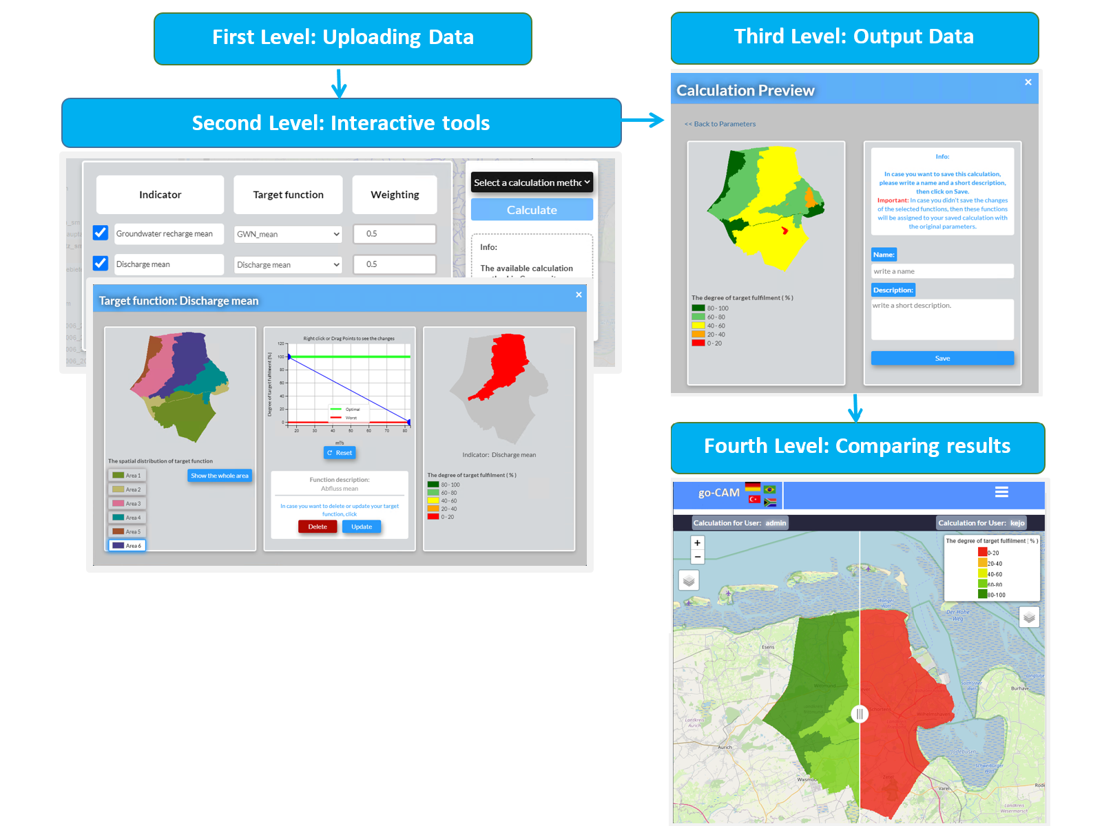
The online platform CAM can be divided into four levels:  1: Data import: meta information and calculated water indicators  2: Interactive selection and weighting of water management options 3: Evaluation of the various indicators with target functions  4: Dialogue process: interactive comparison of results by participating groups
CAM - online dialogue platform @GISCON Geoinformatik GmbH, 2020

The online platform CAM was developed to systematically save water indicators generated from climate and demographic scenarios using multi-criteria decision analysis techniques (MCDA). It also enables transparent evaluation/analysis by stakeholders in coastal water management.

The CAM platform offers a bundled and comprehensible representation of the current and future state of coastal hydrology and water management and enables the visualisation and assessment of the effects of future changes. These changes can be made visible with the CAM and serve as a basis for evaluation and discussion by stakeholders. This makes it possible to develop integrated adaptation strategies and to evaluate new model calculations in the CAM.

The first version of the CAM dialogue platform is online and accessible to various users such as water agencies, competent authorities, water suppliers and soil and water associations worldwide.

Since the platform was developed as part of a joint research project (go-CAM), it is subject to a constant development process. Although the idea and realization of the CAM platform arose out of the challenges in the coastal water management, it is also applicable to other geographic regions.

The CAM platform can be divided into four levels (processing phases):

  1. Data import of calculated water indicators from scenarios, target functions, additional metadata.
  2. Interactive selection, parameterization of the objective function and weighting of indicators of the simulated adaptation measures.
  3. Individual evaluation of the “scenario indicators” via MCDA (indicators – target functions) by the actors involved, visualization of the evaluation.
  4. Participatory dialogue process between the actors; changes to the evaluation criteria (target functions) if necessary; consensus-finding phase.

The online CAM platform is available at gocam.giscon.de.

Water resource: Drinking water, Groundwater, Rainwater, Surface water
Type of product:
  • Management concepts & assessments
  • Modelling & software tools
  • Monitoring & analytics
TRL: 7
    TRL (Technology Readiness Level)
  • TRL 1 - Basic principles observed
  • TRL 2 - Technology concept formulated
  • TRL 3 - Experimental proof of concept
  • TRL 4 - Technology validated in lab
  • TRL 5 - Technology validated in relevant environment (industrially relevant environment in the case of key enabling technologies)
  • TRL 6 - Technology demonstrated in relevant environment (industrially relevant environment in the case of key enabling technologies)
  • TRL 7 - System prototype demonstration in operational environment
  • TRL 8 - System complete and qualified
  • TRL 9 - Actual system proven in operational environment (competitive manufacturing in the case of key enabling technologies; or in space)
Application sector: Agriculture, Cities and municipalities, Industry, Natural water environment, Water resource management
Funding measure: GRoW
Project: go-CAM

Contact and partners


Logo GISCON Geoinformatik GmbH
  • GISCON Geoinformatik GmbH,
  • Mallinckrodtstraße 320,
  • 44147 Dortmund
http://www.giscon.de
Dipl.-Geoökol. Michael Sander

GISCON Geoinformatik GmbH,
Dortmund

Media library


This site uses third-party website tracking technologies to provide its services. I agree to this and can revoke or change my consent at any time with effect for the future.

Settings Decline AcceptLegal NoticePrivacy Policy