The water system model for the Hessian Ried, as part of the Rhine-Main metropolitan region, is an online tool that uses modeling to analyse and depict future developments in the region’s water balance, thereby serving as a basis for strategic decision making and planning by various stakeholders (agriculture and forestry, nature conservation, public water supply, and water management authorities). It is based on various scenarios as well as a broad spectrum of potential measures, which are evaluated with regard to different aspects.
The Hessian Ried region has a long history of conflicts over land use between agriculture, forestry, nature conservation, residential areas, and public water supply, which affect both the quantity and quality of groundwater.
The water system model integrates the results of various numerical models into scenarios with different assumptions regarding global warming, population growth, water consumption, and land-use change, and identifies potential measures to address future challenges.
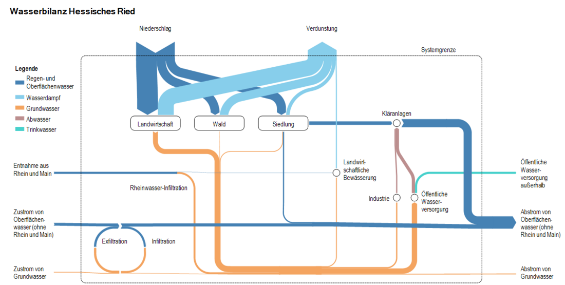
The model results are presented in an interactive online tool where users can compare the scenarios and the impacts of the selected set of measures using Sankey diagrams of the water balance and maps of groundwater levels. In addition, information is provided on the potential impact and the classification of individual measures into the categories “Core Measure,” “No-Regret,” “Accompanying,” and “Case-by-Case Assessment.”
The water system model serves to inform affected stakeholders from agriculture, forestry, nature conservation, urban areas, and public water supply about the expected development of the water balance and the effects or limitations of various options for action. This is intended to serve as a basis for defusing existing (and likely intensifying due to climate change) conflicts over water use. The water system model thus represents a novel, innovative approach to the model-based analysis and compact integration of relevant subprocesses of the water balance and water management.