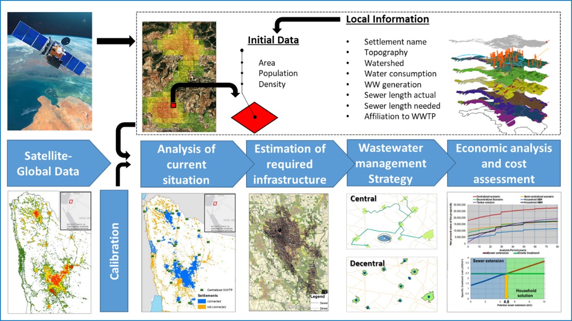
The SWAMP tool facilitates the determination of wastewater generation across scales and, based on that, the comparison of cost estimates for the expansion of wastewater treatment and reuse infrastructure.
The SWAMP tool was developed during the SALAM initiative. It enables a regional wastewater and reuse master planning with high spatial resolution. The tool was developed to forecast the wastewater potential for the year 2050 for Jordan and the West Bank and to estimate the required investments in wastewater disposal and reuse infrastructure.
The SWAMP tool addresses the following questions for the development of wastewater master plans:
- Where and how much wastewater is generated locally?
- Where and how much wastewater is already being treated?
- Where and how much wastewater will need to be treated in the future?
- How should the wastewater be collected?
- Where and how should the wastewater be treated?
- Where the treated wastewater should be reused?
- How should the treated wastewater be transported?
- What are the costs of alternative wastewater disposal and reuse options?
The basis for the regional wastewater management and reuse are raster data (250 m x 250 m) on built-up area and population density generated from open-source data (Global Human Settlement Layer, 2019). A dataset of 34,230 cells for Jordan and a dataset of 10,170 cells for the West Bank were created by extracting the spatial data. These data were cross-checked and supplemented with local information such as population, villages, governorates, road network, topography, connection degree, and water consumption to generate detailed proxy data for each grid cell.
The SWAMP tool is thus transferable to other regions and allows, at different scales (regional, local), both an assessment of the current wastewater management situation and the development of technical expansion options and forecasts of wastewater generation and potential reuse of treated wastewater.